Historical Documents, Maps & More
-

Original Louisiana Purchase Plat's
-
Louisiana Purchase Field Note Index
-

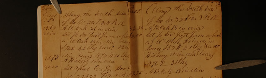
Original Handwritten Field Notes
-
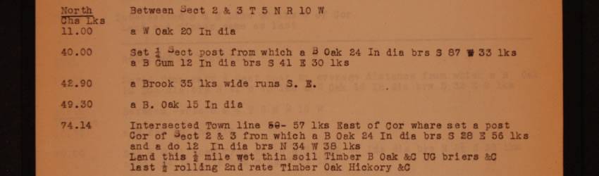
Transcribed Field Notes
Documents |
Louisiana Purchase |
|
The Journey Began In Arkansas"Everything….must have a beginning and the public land survey of Arkansas is no exception. Over in eastern Arkansas where Monroe, Lee and Phillips Counties all join at a common point, is located the point where all the surveys have their beginnings." Claude A. Rankin, Arkansas Land Commissioner (1943-1954)
The official surveying of land that made up the Louisiana Purchase began in October of 1815 when President James Monroe commissioned surveyors Prospect Robbins and Joseph Brown to begin laying out the first surveys west of the Mississippi River. In a swamp in east Arkansas, they established the intersection of the baseline and fifth principle meridian. From that “initial point”, land(s) all the way to the Canadian border including the states of Arkansas, Oklahoma, Kansas, Nebraska, Missouri, Iowa, North & South Dakota, parts of Minnesota and much of the American west (Colorado, Wyoming & Montana) would later be surveyed. This spot lay essentially forgotten until a boundary dispute arose between Lee and Phillips counties in 1921. Local surveyors E. P. Douglass and Tom Jacks were hired to resurvey the line and in the process they "re-discovered" the two sweet gum trees that were slashed by Brown and Robbins 106 years earlier. As a result, in 1926 the L’Anguille Chapter of the Daughters of the American Revolution designated the spot with a concrete marker. In 2002, while preparing to celebrate the 200 year anniversary of the "greatest land deal in history"; the initial point was again resurveyed. Using today’s modern technology including lasers and GPS (global positioning system) imaging it was discovered that in the fall of 1815, in a black water swamp, in the middle of the wilderness, they missed the intersection point by almost 1 inch!
It has been said that Lewis & Clark received all of the glory but the first surveyors of the Louisiana Purchase were the real explorers. Using only a compass and chains and stopping every half mile to mark or “blaze” a tree, they saw the “frontier” one foot at a time. The following images are the original survey field notes of the Louisiana Purchase. These are the actual notebooks that were carried, signed and dated by the surveyors themselves.
Important note(s): Unfortunately, over the many decades some the field books have been lost. If you are researching a particular legal description that can’t be found in original notes, please contact the Commissioner of State Lands Office. Due to the legibility of the hand writing, the original notes were transcribed in the 1870’s creating a second volume of survey notes. It is possible the missing information may be contained in these records.
|