Historical Documents, Maps & More
-

Lovely Donations
-
Lovely Donations
-
Lovely Donations
Documents |
Lovely Donations (1828) |
VIEW IMAGES |
|
Lovely donations were a result of the Cherokee Treaty of 1828 and were named in honor of Major William Lewis Lovely who served as the Arkansas Cherokee Indian agent from 1813 until his death in 1817. During his tenure, he is most recognized for his attempt to resolve the ongoing hostilities between the Osage and Cherokee Indian nations. His solution was the purchase of a large tract of land from the Osage Indian tribe to serve as a buffer zone between the two nations. This tract was later briefly known as Lovely County encompassing what are currently Benton and Washington counties in Arkansas and approximately 200 square miles in northeast Oklahoma. Unfortunately, his attempt met with little success resulting in the 1828 Treaty.
The Treaty created the boundary between the Arkansas Territory and Cherokee Indian Nation by establishing a line from the corner of Missouri down to Fort Smith. This line still serves as the Oklahoma-Arkansas boundary. It also gave the majority of what was Lovely County to the Cherokee Indians, thus providing them a permanent home. Tahlequah, OK, is the capitol of the Cherokee Indian Nation to this day. It further required that white settlers be restricted from settling the land. This meant that all white settlers residing on the west side (Oklahoma) of the new line had to move to the east side (Arkansas). The same held true for the Cherokee Indians. They were required to move from the Arkansas territory to the west side of the new line.
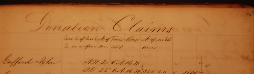
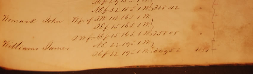
Knowing this would not sit well with many of the white settlers who were being forced off of their property, Congress passed legislation attempting to ease this transition. Each head of household displaced by the Treaty was allowed to claim up to 320 acres of new land in the Arkansas territory free of charge.
Lovely Donations are arranged in alphabetical order.
|